Frequency Chart for the Manhattan, Kansas Area
The following chart lists commonly used radio frequencies in the Manhattan, Kansas area, including amateur, aviation, business, and public safety channels. These frequencies are publicly available and can be monitored with a standard scanner. Monitoring open signals like these can provide a valuable learning experience about radio communication practices, from everyday coordination to community services.
Many public safety and business channels make use of ‘10-codes,’ a system of abbreviated radio signals for common messages (learn more here).
|
35.1600 |
United Telephone Co. |
|
|
36.9000 |
Lifestar helicopter (Fort Riley helicopter boomer operations) |
|
|
37.9000 |
Riley County Public Works |
|
|
39.2200 |
KSG628 |
Morris County Sheriff |
|
39.4000 |
KAA904 |
Riley County Police Dept. dispatch |
|
39.4400 |
Osage County Sheriff |
|
|
39.4600 |
KSG628 |
Morris County Sheriff |
|
39.5000 |
Westmoreland Fire Dept. |
|
|
39.5400 |
Pottawatomie County Sheriff (simulcast on 460.425) |
|
|
39.5600 |
Wabaunsee County Sheriff |
|
|
39.5800 |
Wamego Police dispatch (Kansas police mutual aid freq.) |
|
|
39.7000 |
KSG628 |
Morris County Sheriff (mobile units) |
|
39.7800 |
State Park Rangers (statewide/Tuttle/Milford) |
|
|
43.1400 |
Bayer Construction |
|
|
45.2800 |
Junction City Public Works |
|
|
47.4200 |
Red Cross |
|
|
47.4600 |
Red Cross |
|
|
47.5400 |
Kansas Red Cross |
|
|
47.6200 |
KAH959 |
Public Safety Services - Council Grove |
|
52.5250 |
Nationwide 6m FM simplex frequency |
|
|
110.2000 |
Manhattan Airport VOR |
|
|
118.5500 |
KLS3 |
Manhattan Airport tower / CTAF |
|
121.5000 |
Aviation emergency frequency nationwide (also ELTs) |
|
|
121.8500 |
KLS3 |
Manhattan Airport ground control |
|
122.6500 |
Wichita FSS (Manhattan area calling frequency) |
|
|
122.8000 |
Junction City Airport / Lifestar helicopters / Civil Air Patrol |
|
|
122.8500 |
Manhattan UNICOM (planes to Kansas Air Center) |
|
|
122.9000 |
K63 |
Council Grove Municipal Airport |
|
126.2000 |
Fort Riley Marshall Field tower / Lifestar helicopters |
|
|
127.3500 |
Manhattan link to Kansas City Center (Pilots establish contact with controllers and move to another frequency). |
|
|
145.4100 |
WØQQQ |
KSUARC 2m amateur radio repeater, Manhattan |
|
145.8000 |
International Space Station astronauts |
|
|
146.5200 |
Nationwide 2m FM amateur radio simplex frequency |
|
|
146.6700 |
WAØVRS |
Topeka 2m amateur radio repeater |
|
146.8800 |
NØUZT |
Junction City 2m amateur radio repeater |
|
146.9550 |
KØHAM |
Northeast Kansas ARC 2m amateur radio repeater, St. Mary's |
|
147.2250 |
K-Link Repeater System, Manhattan Repeater (North Central KS storm spotters, Linked Repeaters) |
|
|
147.2550 |
KSØMAN |
MAARS 2m amateur radio repeater, Manhattan |
|
147.5000 |
WARN spotters (simplex) |
|
|
148.1250 |
Junction City Civil Air Patrol - ch. 2 |
|
|
148.1400 |
Civil Air Patrol - aircraft tactical |
|
|
148.1500 |
Junction City Civil Air Patrol repeater / ch. 1 |
|
|
149.4000 |
Civil Air Patrol - air to base |
|
|
149.5400 |
Civil Air Patrol - air to ground |
|
|
151.8050 |
USD 383 Manhattan buses |
|
|
151.9850 |
KJE534 |
Tri-County Telephone Association |
|
152.2300 |
KSDB remote broadcasts |
|
|
152.3900 |
KNAN816 |
Bell Taxi |
|
153.1700 |
KBS311 |
KMAN / KMKF remote broadcasts |
|
154.1600 |
KBG810 |
Manhattan Fire Department |
|
154.4450 |
KAA904 |
Riley County Police Department |
|
154.6000 |
McDonald's drive-through (unverified) |
|
|
154.6800 |
Kansas Turnpike Police |
|
|
154.7250 |
KAA904 |
Riley County Police Dept. Investigations |
|
154.7400 |
Dickinson County Sheriff |
|
|
154.8300 |
Kansas Turnpike Police |
|
|
154.8750 |
KAA904 |
Riley County Police Dept. dispatch |
|
154.9200 |
Kansas Highway Patrol vehicle extenders |
|
|
154.9650 |
KFO985 |
Dickinson County Civil Defense |
|
155.2200 |
Riley County Red Cross |
|
|
155.2800 |
Rock Creek school buses |
|
|
155.2950 |
Onaga School Buses |
|
|
155.3100 |
Kansas Highway Patrol vehicle extenders |
|
|
155.3400 |
KEC398 |
Morris County Hospital |
|
155.3400 |
HEAR System (ambulance dispatch in some areas) |
|
|
155.5650 |
Dickinson County Ambulance |
|
|
155.6100 |
Abilene Police |
|
|
155.7300 |
Crossband between Riley, Geary, Pott. Counties, KSU PD and KHP |
|
|
155.8050 |
WPNR235 |
Riley County Emergency Medical Service |
|
155.8200 |
Wamego Police |
|
|
155.8800 |
Wamego Police |
|
|
155.9250 |
Riley County Fire District #1 |
|
|
156.2250 |
Pottawatomie County Shops |
|
|
158.3400 |
KJE534 |
Tri-County Telephone Association (mobile unit) |
|
158.8050 |
Ogden Public Works |
|
|
162.0750 |
National Weather Service - Kansas City Ch. 3 |
|
|
162.1500 |
National Weather Service - Kansas City Ch. 2 |
|
|
162.4250 |
KZZ67 |
National Weather Service - Blue Rapids |
|
162.4750 |
WXK91 |
National Weather Service - Topeka (via the WIBW tower near Maple Hill) |
|
162.5250 |
WXL71 |
National Weather Service - Abilene |
|
162.5500 |
KID77 |
National Weather Service - Independence, Mo. |
|
162.5500 |
WXK94 |
National Weather Service - Concordia |
|
163.2750 |
National Weather Service - Kansas City Ch. 1 |
|
|
163.4350 |
U. S. Army Corps of Engineers / Riley County Police can use this frequency. |
|
|
165.5875 |
National Weather Service - Kansas City |
|
|
166.0250 |
National Weather Service - Kansas City (assigned) |
|
|
166.2500 |
KJCK remote broadcasts |
|
|
172.1000 |
National Weather Service - Kansas City (assigned) |
|
|
173.3963 |
WPDH708 |
Morris County Rural Water District |
|
203.7500 |
KTWU |
KTWU - 11 audio carrier |
|
215.7500 |
WIBW |
WIBW - 13 audio carrier |
|
410.7625 |
Fort Riley field exercises |
|
|
442.7500 |
K-Link Repeater System, Clay Center Repeater (North Central KS storm spotters) |
|
|
444.1750 |
WØQQQ |
KSUARC 440 MHz amateur radio repeater |
|
444.8500 |
K-Link Repeater System, Minneapolis Repeater (North Central KS storm spotters) |
|
|
451.3000 |
AT&T |
|
|
451.4500 |
KLB260 |
Southwestern Bell Telephone Co. |
|
451.5000 |
Sprint Telephone Co. |
|
|
453.1750 |
Geary County Rural Fire |
|
|
453.2000 |
Pottawatomie County Ambulance dispatch |
|
|
453.3000 |
Pottawatomie County Fire Comm |
|
|
453.5000 |
Pottawatomie County Sheriff (ch. 2 - 7) (Each repeater has a different CTCSS tone - - same input and output freqs). |
|
|
453.6000 |
KUZ802 |
Manhattan Public Works |
|
453.7250 |
Manhattan Sunset Zoo / Milford State Lake Park Rangers |
|
|
453.7750 |
Wamego City Hospital / Pottawatomie County Ambulance |
|
|
453.9500 |
Clay County Emergency Services |
|
|
457.1525 |
McDonald's drive-through - Junction City |
|
|
458.5000 |
Pottawatomie County Sheriff |
|
|
458.9000 |
WNUA287 |
Fire District #9 mobile units (Council Grove) |
|
460.0250 |
Salina Police Dept. |
|
|
460.1000 |
Junction City Police |
|
|
460.1250 |
Grandview Plaza Police |
|
|
460.2250 |
Milford Fire Department |
|
|
460.4250 |
Pottawatomie County Sheriff (ch. 1) |
|
|
460.5000 |
Geary County Sheriff |
|
|
460.5500 |
Saline County Fire Districts |
|
|
460.5750 |
Salina Fire Department |
|
|
460.6250 |
Junction City Fire Dept. |
|
|
461.4250 |
Wamego school buses |
|
|
462.9750 |
WXJ378 |
Riley County Ambulance Service MED-10 |
|
462.9750 |
Irwin Army Hospital base MED-10 Lifestar helicopter Junction City Ambulance |
|
|
463.0000 |
Dickinson County Ambulance to Abilene Hospital |
|
|
463.1500 |
WXJ380 |
Inter-city ambulance service MED-7 |
|
463.9000 |
WNUA287 |
Fire District #9 (Council Grove) |
|
464.4250 |
Manhattan Wrecker Service |
|
|
467.9750 |
Irwin Army Hospital Mobile |
|
|
822.9375 |
Kansas Highway Patrol - car to tower |
|
|
|
One of the next seven KSU frequencies carries data, and will lock up your scanner unless you have a trunk tracker. Work around this by locking out the data channel. If you do have a trunk tracking scanner, you can use the codes in the chart below to make your scanner follow the talk groups you're interested in. |
|
|
|
|
|
|
854.9625 |
WPFQ566 |
KSU Police, Facilities, Housing, etc. (trunked) |
|
855.7125 |
WPFQ566 |
KSU Police, Facilities, Housing, etc. (trunked) |
|
856.7125 |
WPFQ566 |
KSU Police, Facilities, Housing, etc. (trunked) |
|
857.7125 |
WPFQ566 |
KSU Police, Facilities, Housing, etc. (trunked) |
|
858.7125 |
WPFQ566 |
KSU Police, Facilities, Housing, etc. (trunked) |
|
859.7125 |
WPFQ566 |
KSU Police, Facilities, Housing, etc. (trunked) |
|
860.7125 |
WPFQ566 |
KSU Police, Facilities, Housing, etc. (trunked) |
|
866.3750 |
Riley County Ambulance Service (trunked) |
|
|
866.4000 |
Riley County Ambulance Service (trunked) |
|
|
866.7875 |
Riley County Ambulance Service (trunked) |
|
|
867.2000 |
Kansas Department of Transportation - Wamego |
|
|
867.2875 |
Riley County Ambulance Service (trunked) |
|
|
867.9375 |
Kansas Highway Patrol - Topeka (trunked) - Pott. County tower in St. George |
|
|
868.0500 |
Riley County Ambulance Service (trunked) |
|
|
868.2750 |
Riley County Ambulance Service (trunked) |
|
|
868.3000 |
Riley County Ambulance Service (trunked) |
|
|
937.4250 |
Westar |
|
|
937.4500 |
Westar |
|
|
937.4625 |
Westar |
Acronyms
- CTAF = Common Traffic Advisory Freq., used by pilots to advise others of intentions (when tower is closed)
- ELT = Emergency Locator Transmitter (onboard aircraft, activated by impact, downward sweeping audio tone)
- FSS = Flight Service Station, a government weather and flight plan filing service for general aviation
- HIWAS = Hazardous Inflight Weather Advisory Service (recordings of forecasts over selected VORs)
- MAARS = Manhattan Area Amateur Radio Society
- MARTI = brand name of a common low-power broadcast industry remote transmitter
- MAST = Military Assistance to Safety and Traffic
- PAWS = Pottawatomie (County) Amateur Weather Spotters
- UNICOM = a local freq. for advisories on fuel availability, weather, or calling other aircraft (small airports)
- VFR = Visual Flight Rules, which means the generally clear skies required for pilots not instrument rated (IFR)
- VOR = VHF Omni Range, a localized aviation navigation system with CW id and sometimes weather info (HIWAS)
- WARN = Weather Amateur Radio Network
Notes
- The KSU 800 MHz frequencies are for a Motorola trunked system. Four freqs. must be scanned for full coverage.
- 800 MHz frequencies assigned to the Riley County Ambulance Service are for GE trunked mobile units that have phone patch capability. These radios are used infrequently.
- Please email additions or corrections.
Cool Scanner Links
- Association of Public Safety Communications Officials
- Bearcat Radio Club
- Kansas Repeaters via Ham-Shack.com
- K-Link Repeater System, KSØLNK site
- Laws, Rules and Regulations
- National Weather Service
- NOAA Weather Radio nationwide info
- NOAA Weather Radio Station List nationwide info
- Percon Corp. a commercial source of scanner freq. CDs, etc.
- Police Call Directories commercial publisher
- Randy Harrison's Scanner Page Pott / Riley Co. freqs.
- Radio Reference.com
- Scanner World, USA
- Trunking Information (NTIA)
- Trunk Tracker Fleet Codes (Kansas)
- Uniden Corporation home of the Bearcat scanner
- VHF/UHF Scanning
- Wichita Area Scanning Site
Radio Reference.com Links for the Manhattan, Kansas Area
- Radio Reference.com Main Site
- Manhattan and Riley County
- Fort Riley 1
- Fort Riley 2
- Kansas State University
- Kansas Statewide Interoperable Communication System (KSICS)
- Manhattan Businesses
- US Army Corps of Engineers
- Westar Energy - Kansas and Missouri
Contributors to our Frequencies List
- John Skare, NØPVT, Professional Scanner Operator (major contributor)
- Myron Calhoun, WØPBV (major contributor)
- Jay Holmes, KCØNER (major contributor)
- David Yoder, KAØJPM
- Bob Bartholic, KBØZWK
- Paul Schliffke, NØUZN
- Tracy Tipping, NØOEY
- John Best, NØTOK
- George Moore, KD7KXH
- Thomas Lussen, WA4ILH
- Scott Kamla
- Dave Geist
- Eric Ward
- Randy Harrison
- Derek Nester
- Michael Kraft
Hospital & Ambulance Frequencies
| Hospital | Desingation | Vehicle |
| 462.9500 | Dispatch 1 | 467.9500 |
| 462.9750 | Dispatch 2 | 467.9750 |
| 463.0000 | MED 1 | 468.0000 |
| 463.0250 | MED 2 | 468.0250 |
| 463.0500 | MED 3 | 468.0500 |
| 463.0750 | MED 4 | 468.0750 |
| 463.1000 | MED 5 | 468.1000 |
| 463.1250 | MED 6 | 468.1250 |
| 463.1500 | MED 7 | 468.1500 |
| 463.1750 | MED 8 | 468.1750 |
| 462.9500 | MED 9 | 467.9500 |
| 462.9750 | MED 10 | 467.9750 |
A Brief Description of Trunked Radio Systems
The installation of trunked systems has brought a great deal of change to radio listening in the last few years. We recommend that you first hear from the experts, Uniden®, in their page Deciphering Trunked Systems. They're the current owners of the line of scanners known through the years as Electra Bearcat®.
An 800 MHz trunk system has multiple frequency pairs (input/output; the input side always exactly 45 MHz below the output) (minimum three pairs / maximum 29 pairs) used to service several units/stations. There may be as many as 1000 users broken into several groups which use the five frequency pairs. The central controller keeps up with all the users and the status of the five frequencies. When a user keys up a radio, the radio sends out a digital burst which identifies which radio it is and what group it is in. The controller then sends out a "wake up" signal to all the other radios in that group and the transmission is heard by all the radios in that group. It's basically a digital tone-encoded squelch system with a central computer which keeps up with which frequencies are in use, and automatically changes groups to open frequencies when a transmission is made.
On Motorola systems, one of the frequencies will be used for the control channel. Voice traffic may be assigned to the "closest" frequency first, and then to increasingly distant frequencies if the closer ones are busy, etc.
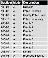
Currently, KSU has multiple groups (including KSUPD, Parking Services, Bramlage Coliseum, Facilities, Housing, and Rec Complex) in its system.
Aviation Communications in the Manhattan Area
Those who would like to monitor aviation communications will need a scanner which receives AM signals in the 118 - 136 MHz range. Around Manhattan, a fair amount of activity can be heard with an indoor antenna.
The Manhattan airport has a cute little tower which is in service from about 8 A.M. to 6 P.M. Its frequency is 118.55 MHz (AM). Pilots of all approaching planes must call in from 10 nautical miles out to announce their presence in our class D airspace. The tower will advise the runway in use, altimeter reading and winds info. Pilots must again contact the tower when entering the runway traffic pattern (downwind leg), and will be given any further instructions. When the tower is open, Manhattan is in controlled airspace.
When the tower is closed, pilots still use the tower frequency (CTAF), announcing their intentions and progression through the runway traffic pattern, even controlling the runway lights intensity with their PTT buttons on the CTAF.
The ground control frequency of 121.85 is of much less interest, and much more difficult to receive, because planes only use it while taxiing. Clearance to take off is requested on the tower frequency.
General aviation pilots around Manhattan, for the most part, keep their radio tuned to the CTAF of the closest airport (if there's a tower), or the UNICOM frequency for that airport if there is no tower. UNICOM at the Manhattan airport is used primarily for a pilot who wishes to contact the Kansas Air Center, a commercial fixed base operator (FBO), for weather info, fuel info, or other needs. The Kansas Air Center is open longer hours than the tower, but does not do air traffic control.
Pilots who are destined for the class B airspace of Kansas City International (Kansas City Center on the radio) call through a remote link which in the Manhattan area is on 127.35 MHz. To keep this frequency clear, the controller who answers will immediately assign each pilot a different frequency for further communications.
Filing flight plans is required for commercial pilots and general aviation pilots flying by instrument (IFR). Most details of the flight plan are often filed by telephone in advance, then "opened" or "activated" by radio promptly after take-off. (The flight plan tells the FAA what route will be taken as well as estimated time enroute, so "opening" it basically starts the FAA "clock" ticking). In this area, flight plans are filed or updated with a federal Flight Service Station (FSS) in Wichita (Wichita Radio) on 122.65, which is easily contacted by a plane aloft. The FSS also gives and receives weather info for the region.
Many airports have a VOR, which is basically a homing signal that onboard instruments can use to see if they are on course. VOR signals are unmanned and not very interesting, and identify in Morse Code (Manhattan's is "MHK"). The local VOR is on 110.2 MHz.
Radio Frequency Spectrum
There are many lists and charts of radio services, and frequency ranges they may use.