Kansas Climate Summary: September 2026
Check out the Kansas Climate Summary for September 2026 from K-State Assistant State Climatologist, Matthew Sittel.
The report offers a useful snapshot of the conditions your clients and crews have been working through, including recent temperature and precipitation patterns by region, drought status changes, growing degree days, and evapotranspiration data that can inform irrigation and plant stress decisions.
–
Kansas Climate Summary September 2026
By Matthew Sittel, Assistant State Climatologist
September was Kansas’ 13th consecutive month with an above normal average temperature. This ties for the longest stretch of consecutive warmer than normal months, set in 1920-21. More significantly, last month was the warmest September on record. Every day during the month averaged above normal. Eleven days were at least 10 degrees above normal, including a 7-day span from September 2 through 8. The hottest temperatures of the month were recorded during this stretch, the most intense portion of a 10-day run at the beginning of September during which multiple stations across southern Kansas reached 100 degrees every day. More than 150 daily record highs were either set or tied, including at Webster Dam in Rooks County, where the 108° high on the 4th was the month’s highest temperature. Morning lows were also unusually warm, with over 200 records set or tied for warmest daily minimums during the same 10-day period. More than a dozen new records for warmest morning low in the month of September were set, including an 82° low at Wilson Lake in Russell County on the 3rd, breaking the old record of 80° which was tied on the 1st and 2nd. There were additional hot days during the remainder of the month. The co-operative observer at Ashland recorded 20 90-degree days in September, and 15 of those were 100-degree days as well. The lack of cool air was also noteworthy. The coldest reading in the state during September was 49°, recorded on the 27th by the Hamilton County Mesonet site near Syracuse. The absence of cold air also set records. For example, the coldest reading in September at Goodland was 50°. This was the first time in their 132-year station history in which they failed to fall into the 40s. A similar occurrence happened in Wichita, where September’s low of 60° was the first time since records began in 1888 that they stayed out of the 50s all month long.
The statewide average temperature for September was 77.3°, or 8.5° above normal. This was the warmest September out of 132 years of NCEI data, dating back to 1895, breaking the old record of 76.7° set in 1931. Divisional departures were all positive, ranging from +6.9° in northwest to +10.1° in southeast Kansas. It was the warmest September on record in all nine climate divisions. Southeast Kansas had the largest margin of victory over the old record; the 2026 average of 80.4° was 1.4° above the old record and was also the warmest of the nine divisions last month. In addition, it was the first time any climate division in the state averaged more than 80 degrees for the month of September. Ninety of Kansas’ 105 counties had their warmest September too. Of the 15 counties where it wasn’t warmest, 13 placed second and two finished at third warmest. Departures from normal for the month ranged from +6.3° in Rawlins County to +11.0° in Butler County. Butler was also the warmest county in the state, with a September average temperature of 81.5°. Cheyenne County was coolest at 72.1°.
The year continues to be on a record pace as well. The state average temperature for January-September 2026 was 62.9°, or 4.3° above normal. This year’s average so far is the warmest January-September on record. The same superlative is true for the western and central climate divisions. In eastern Kansas, southeast is tied for first with 2012, while northeast and east central Kansas rank second, around one degree behind 2015. A total of 68 counties are experiencing their warmest year on record, with 32 more in second place and 5 in third place. Barber County is the most ahead of normal for the year with a departure for the year to date of +5.1 degrees. Linn, Marshall, and Nemaha Counties have the smallest departures from normal at +3.3 degrees.
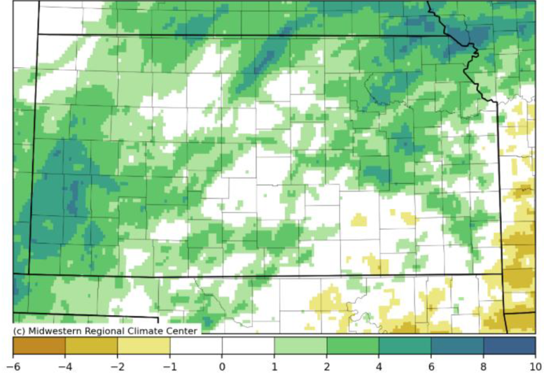
Precipitation in September was above normal for most of the state. The highest total for the month was 11.34” recorded by the co-operative observer south of Burr Oak in Jewell County. Two other counties had reports of more than 10 inches of rain for the month: Doniphan (10.18”, Highland 4.0 E) and Chase (10.01”, Cottonwood Falls 0.7 SSE). Most totals across northeast Kansas were in the 5 to 8-inch range, with a few higher amounts. Four observers in Nemaha County had between 8.75 and 9.65 inches for the month. In Pottawatomie County, five CoCoRaHS observers all reported between 8.1 and 8.8 inches of rain in September. Parts of southwest and west central Kansas also had generous amounts of rainfall. Most totals in these two divisions were in the 3 to 6-inch range, but there were some higher totals, including 8.76” in Greeley County (Tribune 6 NE; Kansas Mesonet), 8.51” in Stanton County (Manter 11.3 SW; CoCoRaHS), 7.90” in Kearny County (Kendall 3.3 SE; CoCoRaHS), and 7.04” in Morton County (Richfield; Kansas Mesonet). Very few locations were significantly below normal for the month. There were a few isolated areas in which less than two inches of rain fell during the month. Far northwestern Kansas was one area; the CoCoRaHS observer 10 miles west-northwest of Goodland recorded the state’s lowest amount for the month of 0.81”. This was much lower than Goodland’s official total of 2.70”. Parts of Rooks County also had less than two inches, including a 1.28” in Palco, but again this was an isolated amount as the Mesonet site north of Plainville had 3.01” for September.
The average monthly precipitation across Kansas for September was 4.06”, or 1.54” above normal. This ranks as the 21st wettest September in 132 years of records and was the wettest September since 2016. All divisions were above normal, with departures ranging from +0.37” in southeast to +3.21” in northeast Kansas. Southwest Kansas had their 4th wettest September on record, while west central Kansas ranked 5th wettest. Five counties had their wettest September on record: Greeley, Hamilton, Kearny, Stanton, and Wichita. Save for Stanton County, the other four also experienced their warmest September. The wettest county was Brown, averaging 7.83” for the month. Graham County was driest, averaging only 1.37” for the month. Graham was one of ten counties with a below normal average. Cherokee County was the most below normal at -0.83”. The largest positive departure was in Nemaha County at +4.50”.
For the first nine months of the year, the state’s average precipitation was 23.82”, or 0.49” below normal. This ranks as the 57th wettest January-September on record. Four divisions are above normal for the year, with northeast Kansas the most above normal at +5.46”. Northeast is highest ranked at 21st wettest. South central Kansas is the most below normal division at -4.31”, and ranks at 41st driest. Within individual counties, year-to-date totals range from 14.08” in Clark County to 40.72” in Neosho County. Departures range from -7.64” in Rice County to +8.79” in Pottawatomie County. Below normal counties outnumber the above 56 to 49. There are 33 counties at least 2 inches ahead of average, with 34 counties 2 inches or more below normal.
There were 21 reports of tornadoes in the state during September. They all occurred on the 29th and 30th in association with the remnants of Hurricane Polo. As of the time this report was being prepared, the exact number of tornadoes was still undetermined, pending completion of storm surveys. The largest hail report during September was 2” in diameter, recorded in four different counties across three separate days. Most numerous were the 81 reports of severe wind gusts of 58 mph or greater. The peak gust was 87 mph, recorded in Colby on September 10.
The state averaged 717 growing degree days in September. This is 161 above the normal count of 556 for the month. Counts across the Kansas Mesonet ranged from 595 in Cheyenne and Sherman Counties to 806 in Labette County. Total evapotranspiration (ET) across the state in September averaged 4.83” which was just 0.01” below the normal of 4.84”. The average 2-meter wind speed across the state was 6.0 mph, slightly below the normal speed of 6.3 mph for September. The 14th was the windiest day with an average wind speed of 10.4 mph. The most common wind direction during the month, based on hourly data from the Kansas Mesonet, was south (32%), with southeast the second most common (24%). The average dew point across the Kansas Mesonet for September was 62.3°, much above the normal of 54.4°. September 30 had the highest average dew point at 66.6°. Monthly average dew points at Kansas Mesonet sites ranged from 56.2° at Cheyenne to 66.5° at Miami.
To have the monthly Kansas Climate Summary sent directly to your inbox complete with weather graphs and a summary by county, reach out to Matthew Sittel at msittel@ksu.edu.