Technical Details
The Geographic Information Systems Spatial Analysis Laboratory operates Geocat, a state-of-the-art enterprise Geographic Information System (GIS) platform that supports cutting-edge geospatial research, education, and outreach at Kansas State University. Geocat is a cloud-native deployment of Esri’s ArcGIS Enterprise suite, fully hosted and managed through Amazon Web Services (AWS) and supported by ROK Technologies. It is designed to expand in capacity and functionality, including future integration with real-time data streams, AI-based spatial knowledge graphs, and high-performance computing clusters.
Cloud Infrastructure
Geocat is architected to deliver scalable, high-performance, and secure GIS capabilities enabling geographically distributed research and remote instruction through cloud-based infrastructure that
supports real-time collaboration, advanced spatial analytics, and secure access from any location.
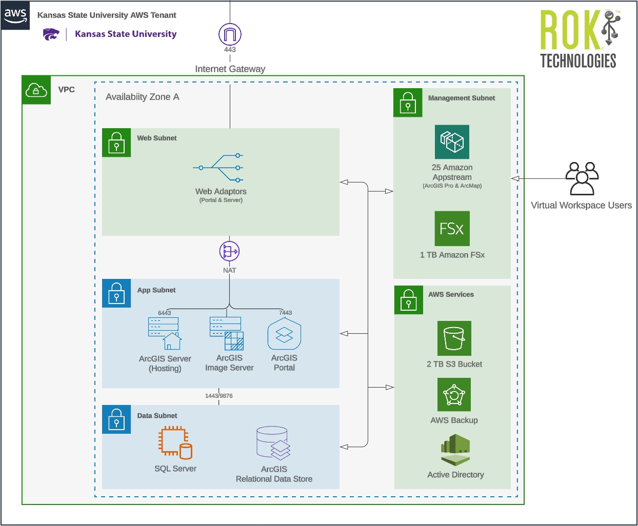
- AWS-hosted ArcGIS Enterprise Stack, including ArcGIS Server, Portal, Image Server, Relational Datastore, and SQL Server.
- Virtualized desktop access via AWS Appstream or GPU-enabled AWS Workspaces (4 vCPUs, 16 GB RAM) optimized for ArcGIS Pro.
- High-IOPS SSD server storage for efficient big data analysis.
- Amazon S3 general-purpose object storage for critical spatial and aspatial datasets.
- FSx file server for shared high-speed access to Geocat data stores via virtual desktops.
- Robust backup protocol including daily snapshots, monthly full backups, and disaster recovery support for virtual machines, relational data stores, and enterprise geodatabases.
SaaS System Architecture
Note: Geocat's AWS Service elements and subnets are dynamic and can scale in response to current operational requirements.
SaaS Back End
| Description | Server Instances | Size |
| ArcGIS Server (Hosting) | 1 | 4 vCPUs 16 GB RAM |
| Portal Server | 1 | 4 vCPUs 16 GB RAM |
| Relational Datastore | 1 | 4 vCPUs 16 GB RAM |
| SQL Server | 1 | 4 vCPUs 32 GB RAM |
| Web Adaptor Server | 1 | 2 vCPUs 8 GB RAM |
| Image Server | 1 | 4 vCPUs 16 GB RAM |
Note: Geocat's production environment, including server instances and vCPU specifications are dynamic and can scale in response to current operational requirements.
Managed Services and Reliability
ROK Technologies, an Esri Platinum Partner and experienced GIS managed service provider, provides comprehensive system management that allows researchers and educators to focus on analysis and innovation rather than infrastructure maintenance.
- Continuous monitoring, performance tuning, and system optimization with 99.5% guaranteed uptime with fully managed cloud infrastructure.
- 24/7 U.S.-based technical support.
- Operating system software updates, security patches, and Esri software upgrades.
- Backup and retention policies ensuring data integrity (e.g., 4x daily geodatabase snapshots, monthly full backups retained for 12 months).
Strategic Support and Interdisciplinary Access
Geocat is supported by both AWS and the Kansas Water Institute, reflecting its strategic importance to K-State’s land-grant mission. Local administration is provided by the Geographic Information Systems Spatial Analysis Laboratory (GISSAL). The system empowers faculty, students, and outreach professionals across multiple disciplines by providing centralized access to advanced spatial tools.